Explore Southwest Georgia
Historic Markers in Decatur County Georgia
| There are 48 Historic Markers in Decatur County.
Also see Historical Markers in |
Historical Markers in
Willis Park & Downtown Bainbridge
- DeSoto Trail
- El Camino Real (The Kings Highway)
- In Memory of Revolutionary Soldiers Who Settled and Died in Decatur County
- First Presbyterian Church
- First United Methodist Church
- Hutto School
- Union Normal School
- First Flint River Baptist Normal Institute
|
Historical Markers in
J. D. Chason Park (Lots of History)
- The J. D. Chason Memorial Park
- The J. D. Chason Memorial Park History
- The Battle of Fowltown
- First Seminole War Trail
- The First Seminole War in Decatur County
- Fort Hughes
- Fort Scott
- The Second Creek War and Removal in the Decatur County Area
|
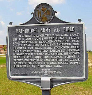
Bainbridge Army Air Field
US 27 4 mi N of Bainbridge at Bainbridge Industrial Park (30.978133 -84.61438)
In August, 1942, on this 2,053 acre tract, the U.S. Army constructed a basic flight training field. It remained open until 1945. At its peak 9600 officers, enlisted men, trainees and WACS were stationed here; there were 700 civilian employees, several hundred WW II German P.O.W.S were imprisoned here. In 1951 southern airways school, a private company, contracted with the U.S.A.F. to train its pilots. The base closed in 1961 and became an industrial park.
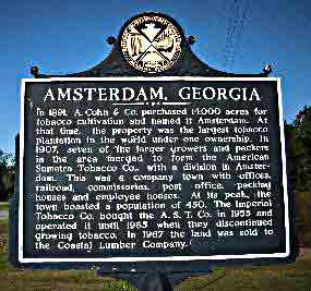
Amsterdam, Georgia
US 27 median at Amsterdam, SE of Bainbridge (30.72691666 -84.43306666)
In 1891, A. Cohn & Company purchased 14,000 acres for tobacco cultivation and named it Amsterdam. At that time, the property was the largest tobacco plantation in the world, under one ownership. In 1907, seven of the larger growers and packers in the area merged to form the American Sumatra Tobacco Company, with a division in Amsterdam. This was a company town with offices, railroad, commissaries, post office, packing houses and employee houses. At its peak, the town boasted a population of 450. The Imperial Tobacco Company bought the American Sumatra Tobacco Company in 1955 and operated it until 1965 when they discontinued growing tobacco. In 1967 the land was sold to the Coastal Lumber Company.
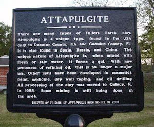
Attapulgite
Located off Englehard Way Attapulgus, Ga. (30.74868333 -84.48586666)
There are many types of Fullers Earth clay. Attapulgite is a unique type, found in the USA only in Decatur County, GA and Gadsden County. Fl. It is also found in Spain, Russia , and China. The unique nature of Attapulgite is, when mixed with fresh or salt water, it forms a gel. With new processes of refining oil, this no longer a major use. Other uses have been developed in cosmetics, paint, medicine, dry wall taping, and oil drilling. All processing of the clay was moved to Quincy in 1998. Some mining is still being done in the area.
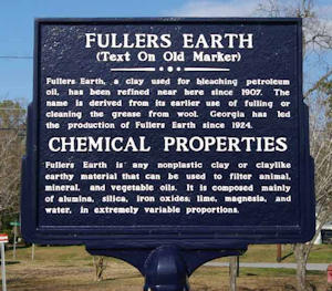 Fullers Earth
, a clay used for bleaching petroleum oil, has been refined near here since 1907. The name is derived from its earlier use of fulling or cleaning the grease from wool. Georgia has led the production of Fullers Earth since 1924.
Chemical Properties
Fullers Earth is any nonplastic clay or claylike earthy material that can be used to filter animal, mineral, and vegetable oils. It is composed mainly of alumina, silica, iron oxides, lime, magnesia, and water, in extremely variable proportions.
Attapulgus
on N. Main St. Attapulgus, Ga. (30.7494 -84.48411666)
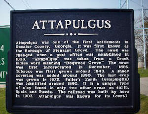
Attapulgus was one of the first settlements in Decatur County, Georgia. It was first known as the Borough of Pleasant Grove. The name was changed when a post office was established in 1838. "Attapulgus" was taken from a Creek Indian word meaning "Dogwood Grove". The town was first incorporated in December, 1866. Tobacco was first grown around 1840. A shade covering was added around 1890. The last crop was grown in 1973. Fuller's Earth (Attapulgite) was identified around 1890. It is a unique type of clay found in only two other areas on earth, Spain and Russia. The railroad was built by here in 1903. Attapulgus was known for its
continued
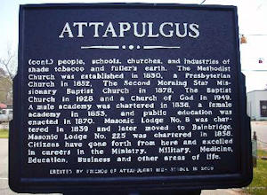
people, schools, churches, and industries of shade tobacco and fuller's earth. The Methodist Church was established in 1830, a Presbyterian Church in 1852, The Second Morning Star Missionary Church in 1928 and a Church of God in 1949. A male academy was chartered in 1838, a female academy in 1853, and public education was enacted in 1870. Masonic Lodge No.8 was chartered in 1839 and later moved to Bainbridge. Masonic Lodge No.225 was chartered in 1858. Citizens have gone forth from here and excelled in careers in the Ministry, Military, Medicine, Education, Business and other areas of life.
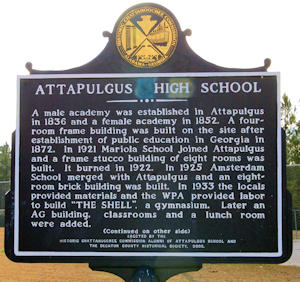
Attapulgus High School
Church Street near the Attapulgus Baptist Church, Attapulgus, GA. (30.74683333 -84.48483333)
A male academy was established in Attapulgus in 1836 and a female academy in 1852. A four-room frame building was built on the site after establishment of public education in Georgia in 1872. In 1921 Mariola School joined Attapulgus and a frame stucco building of eight rooms was built. It burned in 1922. In 1925 Amsterdam School merged with Attapulgus and an eight room brick building was built. In 1933 the locals provided materials and the WPA provided labor to build 'THE SHELL', a gymnasium. Later an AG building, classrooms and a lunch room were added.
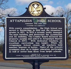
Attapulgus High School
With county consolidation, the High School was moved to Bainbridge in 1966 and the elementary grades in 1971. In 1972 a tornado badly damaged the main building and destroyed the gymnasium and AG building. The County Board declared the property surplus and sold it to Attapulgus Baptist Church in 1973. With dedicated teachers, an excellent curriculum was taught. When the Attapulgus School closed, all teachers held masters degrees or better. Many of the school's graduates went on to higher education, performing as well or better than those from larger schools.
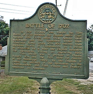
Battle of 1702
Ga 97N just south of Ga 311 intersection in Bainbridge (30.912433 -84.5673)
In this vicinity was fought the Flint Battle of 1702 between the English under Captain Antonio with Creek allies from Achito (near Columbus) and the Spaniards under Captain Francisco Romo Uriz with 800 Indians from Bacuqua (north of Tallahassee). In a battle at daybreak the English defeated the Spaniards, killing or capturing 600. This battle was a prelude to Queen Anne s War and first blow for control for the Mississippi valley by the English. It ended the advance of the Spaniards up the Chattahoochee and Flint valleys and France s ambition in Alabama.
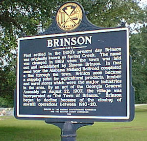
Brinson
In cemetery at US 84 and Ga 310 west of Bainbridge (30.969933 -84.73253)
First settled in the 1850's present day Brinson was originally known as Spring Creek. The name was changed in 1889 when the town was laid out and established by Simeon Brinson. In that same year the Alabama Midland Railroad completed a line through the town. Brinson soon became a shipping point for agricultural products, lumber and metal stores which were the major industries in the area. By an act of the Georgia General Assembly on August 22, 1907, the village was incorporated as "the Town of Brinson." Brinson began to decline because of the closing of sawmill operations between 1910-20.
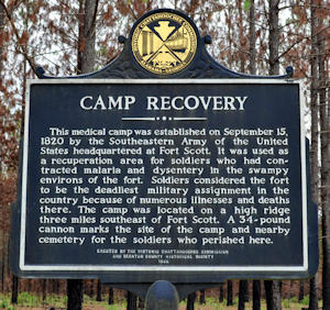
Camp Recovery
Booster Club Road, West of GA Hwy 310, 3 miles north of GA Hwy 97 (30.753961536 -84.731676133)
The medical camp was established on September 15, 1820 by the Southeastern Army of the United States headquartered at Fort Scott. It was used as a recuperation area for soldiers who had contracted malaria and dysentery in the swampy environs of the fort. Soldiers considered the fort to be the deadliest military assignment in the country because of numerous illnesses and deaths there. The camp was located on a high ridge three miles southeast of Fort Scott. A 34-pound cannon marks the site of the camp and the nearby cemetery for the soldiers who perished here.
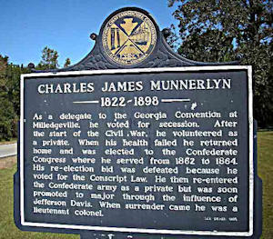
Charles James Munnerlyn 1822-1898
South of Bainbridge on Ga 97 at Green Shade Road, (30.789854399 -84.612718827)
As a delegate to the Georgia Convention at Milledgeville, he voted for secession. After the start of the Civil War, he volunteered as a private. When his health failed he returned home and was elected to the Confederate Congress where he served from1862 to 1864. His re-election bid was defeated because he voted for the Conscript Law. He then re-entered the Confederate army as a private but was soon promoted to major through the influence of Jefferson Davis. When surrender came he was a lieutenant colonel.
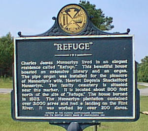
Side 2 - Refuge
Chris John Munnerlyn lived in an elegant residence called "Refuge." This beautiful house boasted an extensive library and an organ. The pipe organ was installed for the pleasure of Munnerlyn's wife. Harriet Eugenia Shackelford Munnerlyn. The family cemetery is situated near this marker. It is located about 800 feet north of the site of "Refuge." The house burned in 1883. The Munnerlyn plantation contained over 3,000 acres and had a landing on the Flint River, It was worked by over 200 slaves.
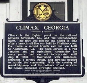
Climax, Georgia
At "Courthouse"/old Depot at park on New St in Climax, (30.881466 -84.429)
Climax is the highest point on the railroad between Savannah, Ga., and the Chattahoochee River. The town was laid out and named in 1883 after a branch rail line was built to Chattahoochee, Fla. Later, a second branch rail line was built to Amsterdam, Ga. The town served as a rail junction and an agricultural community for many years, but was not incorporated until Aug. 11, 1905. It flourished, with businesses, churches, a school, hotels, and services needed to sustain the community. With the coming of paved highways and the cutback of rail services, the town's economic strenght [sic] declined.
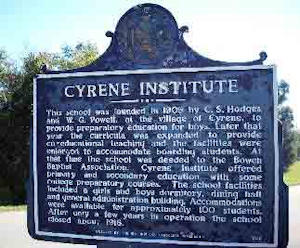
Cyrene Institute
US 84 and Cyrene Rd west of Bainbridge, ((30.942116 -84.6814)
This school was founded in 1909 by C. S. Hodges and W. G. Powell, at the Village of Cyrene, to provide preparatory education for boys. Later that year the curricula was expanded to provide co-educational teaching and the facilities were enlarged to accommodate boarding students. At that time the school was deeded to the Bowen Baptist Association. Cyrene Institute offered primary and secondary education with some college preparatory courses. The school facilities included a girls and boys dormitory, dining hall and general administration building. Accommodations were available for approximately 100 students. After only a few years in operation the school closed about 1916.
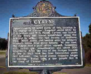
Cyrene (Side 2)
Approximately 1.6 miles north of this location is the village of Cyrene. Founded about 1890 by C. S. Hodges and W. G. Powell, Cyrene was typical of the many mill towns established along the railroad to utilize the vast forests of Southern Pine. Naval stores and lumber were the primary products taken from these forests. At one time, the village had a post office, sawmill, turpentine still, cotton gin, commissaries and about 500 inhabitants. After the loss of the Hodges Sawmill to fire in 1927 and the lean Depression years that followed, the naval stores industry began to decline. Today only a few people live in the town of Cyrene.
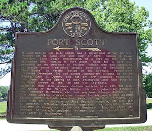
Fort Scott
Ga 310 about 3.5 miles NW of Ga 97, southwest of Bainbridge, (30.769133 -84.73441)
In June 1816 Lt. Col. D. L. Clinch and a detachment of the 4th U.S. Infantry set up camp one mile west of here, calling it Camp Crawford. They began construction of a fort on the site in September 1816, naming it Fort Scott. Need for a fort was prompted by the presence of restless Indians who had emigrated to nearby areas -- refugees largely composed of Seminoles and "Red Sticks" (a hostile faction of the Creeks). Prematurely evacuated December 1816 and almost immediately pillaged by hostile Indians, Capt. S. Donoho and his artillery company reoccupied Fort Scott in the Spring of 1817, reinforced later that year by additional troops of the 4th and 7th Regiments.
March 9, 1818, Gen. Andrew Jackson arrived here with his staff and troops of the Georgia Militia. He was joined by Kentucky and Tennessee militiamen, who had marched through Alabama. At fort Scott Jackson concentrated troops for his march into Spanish Florida against Indians who had been raiding U.S. territory. He took with him the force at Fort Scott, excepting 60 men left as garrison. Following Jackson's campaign the garrison largely consisted of companies of the 7th Regiment. Frontier peace and increase of malaria probably account for the abandonment of Fort Scott in September 1821.
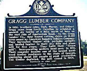
Gragg Lumber Company
on Hwy US 27 North SE of Bainbridge (30.72695 -84.43293333)
SIDE 1: In 1926, brothers John, Earl, Wayne and Gilbert Gragg came from North Carolina to establish a sawmill six tenths of a mile north of here on the east side of Amsterdam Road. As the Gragg Lumber Co., they leased cutting rights on 16,000 acres owned by American Sumatra Tobacco Company. They harvested timber with portable sawmills and hauled lumber to their dry kiln and plane mill for five years. They built their "dream mill", incorporating modern band saws, in 19(30. Their company became one of the largest hardwood lumber producers in the state of Georgia, employing about 200 people at peak production. The timber depleted, the mill closed in 1944.
SIDE 2: From Virginia in the north, stretching south to Texas and bounded by the Piedmont and by mountians to the west, there was once a carpet of Green Gold. This fabulous carpet was long-leaf and slash pine, including oaks here. It attracted sawmill and turpentine industries to Decatur County. These industries yielded economic stability in this region during the first half of the twentieth century. The longleaf pine once covered 130 million acres. Its area is now reduced to about 3 million acres. The cathedral like beauty of longleaf stands and wide use of the gave it the crown of "one of the greatest trees ever known."
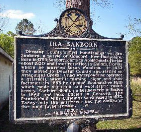
Ira Sanborn
on grounds of the Masonic Lodge, Faceville (30.753166 -84.64151)
Decatur County's first industrialist was Ira Sanborn, a native of Concord, New Hampshire. Born in 1799, Sanborn came to Apalachicola, Florida about 1830 and later resettled in Quincy, Florida where he married Susan Woodson. In 1833 they moved to Decatur County and settled on Attapulgus Creek. Using waterpower he operated a gristmill, sawmill, tanning, cigar and shoe factories. In 1856 he opened Estahatchee Mills which made a cotton and wool fabric called kersey. Sanborn died on a business trip to Boston in 1865 and was buried in Concord. The Estahatchee Mills buildings were razed in 1870. Today only the mill races and the outline of the pond levee remain.
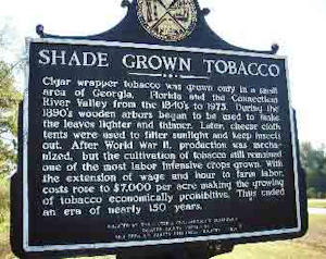
Shade Grown Tobacco
US 27 median at Amsterdam, SE of Bainbridge, (30.72691666 -84.43306666)
Cigar wrapper tobacco was grown only in a small area of Georgia, Florida and the Connecticut River Valley from the 1840 s to 1975. During the 1890 s, wooden arbors began to be used to make the leaves lighter and thinner. Later, cheese cloth tents were used to filter sunlight and keep insects out. After World War II, production was mechanized, but the cultivation of tobacco still remained one of the most labor intensive crops grow. With the extension of wage and hour to farm labor, costs rose to $7,000 per acre making the growing of tobacco economically prohibitive.
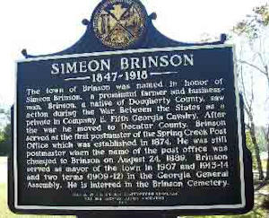
Simeon Brinson 1847-1918
In cemetery at US 84 and Ga 310 west of Bainbridge, (30.969933 -84.73253)
The town of Brinson was named in honor of Simeon Brinson, a prominent farmer and businessman. Brinson, a native of Dougherty County, saw action during the War Between the Sates as a private in Company E, Fifth Georgia Cavalry. After the war he moved to Decatur County. Brinson served as the first postmaster of the Spring Creek Post Office which was established in 1874. He was still postmaster when the name of the post office was changed to Brinson on August 24, 1889. Brinson served as mayor of the town in 1907 and 1913-1914 and two terms (1909-1912) in the Georgia General Assembly. He is interred in the Brinson Cemetery.
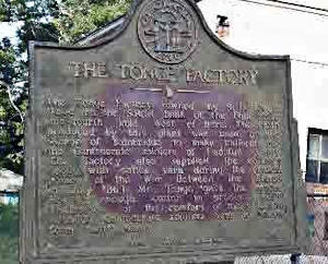
The Tonge Factory
Ga 97N just south of Ga 311 intersection, Bainbridge, (30.912633 -84.56706)
The Tonge Factory, owned by S. D. Tonge, stood on the South bank of the Flint river one-fourth mile West of here. The cloth produced by this plant was used by the women of Bainbridge to make uniforms for the Confederate soldiers of Decatur county. The factory also supplied the county's needy with cotton yarn during the critical period of the War Between the States. In July, 1864, Mr. Tonge gave the Macon Hospital enough cotton to produce 1,200 mattresses for the comfort of the sick and wounded Confederate soldiers sent to Macon from battle areas.
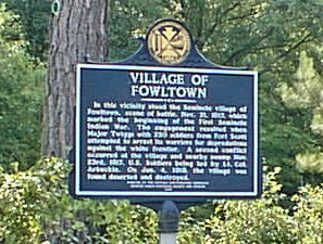
Village of Fowltown
Ga 97 .6 mile north of Green Shade Rd (at tree 40' off rd), (30.799033 -84.61031)
In this vicinity stood the Seminole village of Fowltown, scene of battle, Nov. 21, 1817, which marked the beginning of the First Seminole Indian War. The engagement resulted when Major Twiggs with 250 soldiers from Fort Scott attempted to arrest its warriors for depredations against the white frontier. A second conflict occurred at the village and nearby swamp Nov. 23rd, 1817, U.S. Soldiers being led by Lt. Col. Arbuckle. On Jan. 4, 1818, the village was found deserted and destroyed.
Also See
Historical Markers in Downtown Bainbridge
Historical Markers in Chason Park
Information from Latitude 34 North,
GA Deptof Community Affairs and
galileo.usg.edu